
Efstratios’s guidebook
Sightseeing
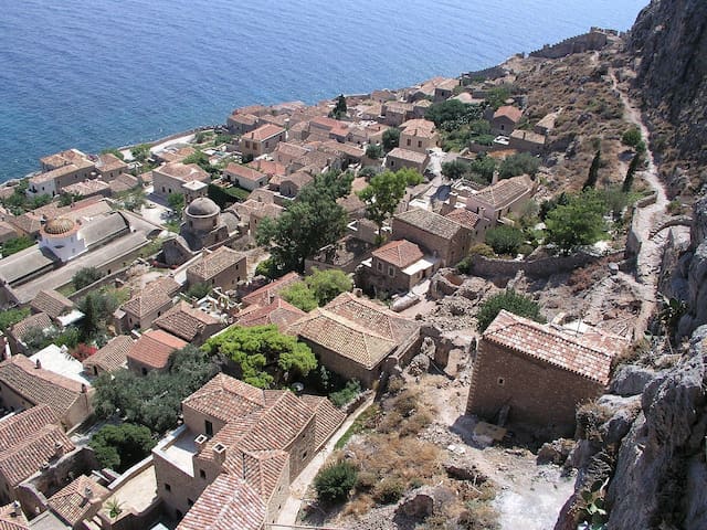
Monemvasia (Greek: Μονεμβασία) is a town and a municipality in Laconia, Greece. The town is located on a small island off the east coast of the Peloponnese. The island is linked to the mainland by a short causeway 200m in length. Its area consists mostly of a large plateau some 100 metres above sea level, up to 300 m wide and 1 km long, the site of a powerful medieval fortress. The town walls and many Byzantine churches remain from the medieval period. The seat of the municipality is the town Molaoi. The town's name derives from two Greek words, mone and emvasia, meaning "single entrance". Its Italian form, Malvasia, gave its name to Malmsey wine. Monemvasia's nickname is the Gibraltar of the East or The Rock.
In 1971, Monemvasia became linked with the rest of the outside world through a bridge on the western side that connects to highway GR-86.
In more recent history, the town has seen a resurgence in importance with increasing numbers of tourists visiting the site and the region. The medieval buildings have been restored, and many of them converted to hotels.
For the past few years, on July 23, an independence day celebration has been held in the main port. Speeches are made and the story of Tzannetakis Grigorakis, and his men, is recounted in both Greek and English. Inhabitants and visitors can gather to watch as a ship, built every year, is filled with pyrotechnics and set on fire.
The 1986 horror movie The Wind was filmed here.
91 localnici recomandă
Monemvasia
Monemvasia (Greek: Μονεμβασία) is a town and a municipality in Laconia, Greece. The town is located on a small island off the east coast of the Peloponnese. The island is linked to the mainland by a short causeway 200m in length. Its area consists mostly of a large plateau some 100 metres above sea level, up to 300 m wide and 1 km long, the site of a powerful medieval fortress. The town walls and many Byzantine churches remain from the medieval period. The seat of the municipality is the town Molaoi. The town's name derives from two Greek words, mone and emvasia, meaning "single entrance". Its Italian form, Malvasia, gave its name to Malmsey wine. Monemvasia's nickname is the Gibraltar of the East or The Rock.
In 1971, Monemvasia became linked with the rest of the outside world through a bridge on the western side that connects to highway GR-86.
In more recent history, the town has seen a resurgence in importance with increasing numbers of tourists visiting the site and the region. The medieval buildings have been restored, and many of them converted to hotels.
For the past few years, on July 23, an independence day celebration has been held in the main port. Speeches are made and the story of Tzannetakis Grigorakis, and his men, is recounted in both Greek and English. Inhabitants and visitors can gather to watch as a ship, built every year, is filled with pyrotechnics and set on fire.
The 1986 horror movie The Wind was filmed here.
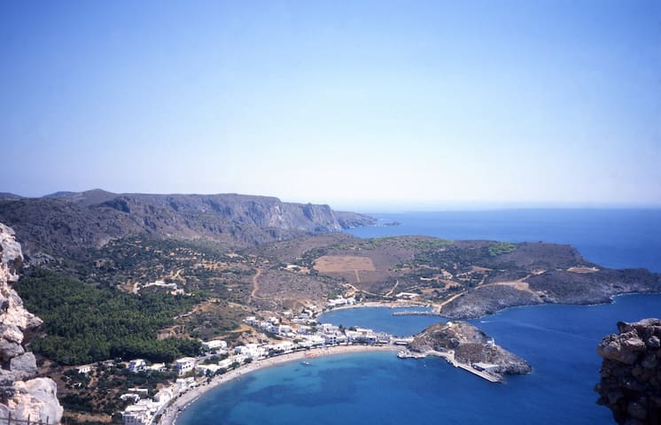
Kythira, also transliterated as Cythera, Kythera and Kithira is an island in Greece lying opposite the south-eastern tip of the Peloponnese peninsula. It is traditionally listed as one of the seven main Ionian Islands, although it is distant from the main group. Administratively, it belongs to the Islands regional unit, which is part of the Attica region (although at large distance from Attica itself).
The island is strategically located between the Greek mainland and Crete, and from ancient times until the mid 19th century was a crossroads of merchants, sailors, and conquerors. As such, it has had a long and varied history and has been influenced by many civilisations and cultures. This is reflected in its architecture (a blend of traditional, Aegean and Venetian elements), as well as the traditions and customs, influenced by centuries of coexistence of the Greek, Venetian, and Ottoman cultures.
Barbary pirates ranged across the Mediterranean waters, raiding ships, coasts and islands, taking booty and slaves for the Barbary slave trade. Kythira was at the mercy of Barbary pirates due to its strategic location in the Mediterrean. In order to intercept merchant vessels, islands along the trade routes were of course more interesting for pirates.[7] In the 17th century the small islands like Sapientza (Kalamatas) south of Messinia (district in south-western part of the Peloponnese), Cergio (Kythira) south of the south-eastern tip of the Peloponnese, and along the coast of Asia minor, the then deserted islands of Fourni southwest of Samos, and the island of Psara, west of Chios, all functioned as pirates nests.[8]
When Napoleon put an end to the Venetian Republic in 1797, Kythira was among the islands incorporated in that most distant départment of France, called Mer-Égée. Kythira shared a common destiny with the other Ionian islands during the turbulent Napoleonic era, and is still regarded as one of them; it was counted as one of the Cyclades in antiquity.
In 1799, the Ionian islands became the Septinsular Republic, nominally under Ottoman suzerainty, but in practice dominated by Russia. In 1807, France took them back only to have the British seize the islands in 1809 and set up one of their first protectorates, the United States of the Ionian Islands. The British held them for nearly half a century; under the British, they were governed by a High Commissioner who could act with both legislative and executive powers. After a long history of turbulence, never settled even by such eminent Commissioners as William Ewart Gladstone for three weeks in the winter of 1859, the British discussion whether they were a waste of money or a vital Imperial possession ended with the cession of the Ionian Islands, including Kythira, to the new King George I of Greece, who was brother-in-law to the Prince of Wales. Under the British, Kythira was known as Carigo or Cerigo, as was its chief town, the name it had under the Venetian Republic.
The chief town of the island, Kythira (or Chora, "village") has the Historical Archives of Kythira, the second largest in the Ionian islands, after Corfu.
8 localnici recomandă
Cythera
Kythira, also transliterated as Cythera, Kythera and Kithira is an island in Greece lying opposite the south-eastern tip of the Peloponnese peninsula. It is traditionally listed as one of the seven main Ionian Islands, although it is distant from the main group. Administratively, it belongs to the Islands regional unit, which is part of the Attica region (although at large distance from Attica itself).
The island is strategically located between the Greek mainland and Crete, and from ancient times until the mid 19th century was a crossroads of merchants, sailors, and conquerors. As such, it has had a long and varied history and has been influenced by many civilisations and cultures. This is reflected in its architecture (a blend of traditional, Aegean and Venetian elements), as well as the traditions and customs, influenced by centuries of coexistence of the Greek, Venetian, and Ottoman cultures.
Barbary pirates ranged across the Mediterranean waters, raiding ships, coasts and islands, taking booty and slaves for the Barbary slave trade. Kythira was at the mercy of Barbary pirates due to its strategic location in the Mediterrean. In order to intercept merchant vessels, islands along the trade routes were of course more interesting for pirates.[7] In the 17th century the small islands like Sapientza (Kalamatas) south of Messinia (district in south-western part of the Peloponnese), Cergio (Kythira) south of the south-eastern tip of the Peloponnese, and along the coast of Asia minor, the then deserted islands of Fourni southwest of Samos, and the island of Psara, west of Chios, all functioned as pirates nests.[8]
When Napoleon put an end to the Venetian Republic in 1797, Kythira was among the islands incorporated in that most distant départment of France, called Mer-Égée. Kythira shared a common destiny with the other Ionian islands during the turbulent Napoleonic era, and is still regarded as one of them; it was counted as one of the Cyclades in antiquity.
In 1799, the Ionian islands became the Septinsular Republic, nominally under Ottoman suzerainty, but in practice dominated by Russia. In 1807, France took them back only to have the British seize the islands in 1809 and set up one of their first protectorates, the United States of the Ionian Islands. The British held them for nearly half a century; under the British, they were governed by a High Commissioner who could act with both legislative and executive powers. After a long history of turbulence, never settled even by such eminent Commissioners as William Ewart Gladstone for three weeks in the winter of 1859, the British discussion whether they were a waste of money or a vital Imperial possession ended with the cession of the Ionian Islands, including Kythira, to the new King George I of Greece, who was brother-in-law to the Prince of Wales. Under the British, Kythira was known as Carigo or Cerigo, as was its chief town, the name it had under the Venetian Republic.
The chief town of the island, Kythira (or Chora, "village") has the Historical Archives of Kythira, the second largest in the Ionian islands, after Corfu.
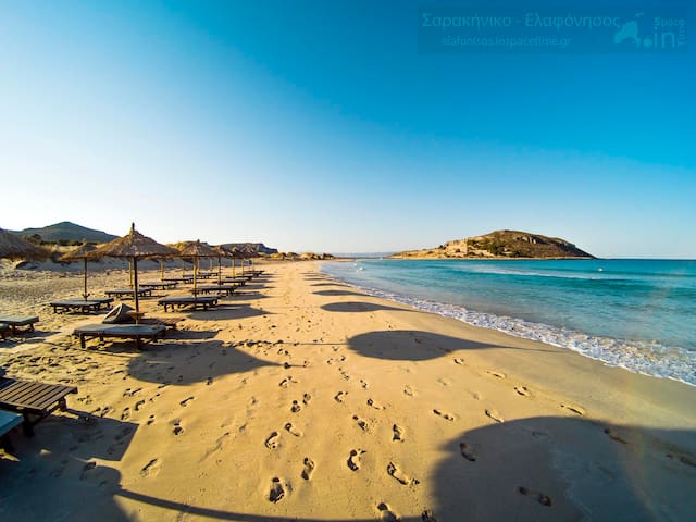
Elafonisos (Greek: Ελαφόνησος) is a small Greek island between the Peloponnese and Kythira. It lies off the coast of Cape Malea and Vatika. The area of the island is 19 square kilometres (7 square miles).
The population is between 300 and 350 during the winter but increases dramatically in the summer months. During July and August the number of tourist visitors reach over 3,000 per day (bringing with them some 1,600 cars). Many people visit the island for its light coloured, sandy beaches. Among the most well known of its beaches are Sarakiniko, Fragos (Simos) and Panagias Nissia, all filled with blue-green waters.
Elafonisos is by far the largest inhabited island in the Peloponnese archipelago, and the only one that is a separate municipality. There are also some archaeological discoveries to explore on the island and in the surrounding waters. The main church of the community is Agios Spyridon (Greek: Άγιος Σπυρίδων), which is built on a tiny separate piece of land which is connected by a bridge over shallow waters to the rest of the island. The community's land area also includes 3 km2 (1 sq mi) of the mainland consisting mainly of the famous Punta Beach.
On the nearby mainland, approximately 6.5 km (4.0 mi) east is Neapoli of the municipality of Vatika. About 8.5 km (5.3 mi) south is Cape Frangos on the island of Kythira.
56 localnici recomandă
Elafonissos
Elafonisos (Greek: Ελαφόνησος) is a small Greek island between the Peloponnese and Kythira. It lies off the coast of Cape Malea and Vatika. The area of the island is 19 square kilometres (7 square miles).
The population is between 300 and 350 during the winter but increases dramatically in the summer months. During July and August the number of tourist visitors reach over 3,000 per day (bringing with them some 1,600 cars). Many people visit the island for its light coloured, sandy beaches. Among the most well known of its beaches are Sarakiniko, Fragos (Simos) and Panagias Nissia, all filled with blue-green waters.
Elafonisos is by far the largest inhabited island in the Peloponnese archipelago, and the only one that is a separate municipality. There are also some archaeological discoveries to explore on the island and in the surrounding waters. The main church of the community is Agios Spyridon (Greek: Άγιος Σπυρίδων), which is built on a tiny separate piece of land which is connected by a bridge over shallow waters to the rest of the island. The community's land area also includes 3 km2 (1 sq mi) of the mainland consisting mainly of the famous Punta Beach.
On the nearby mainland, approximately 6.5 km (4.0 mi) east is Neapoli of the municipality of Vatika. About 8.5 km (5.3 mi) south is Cape Frangos on the island of Kythira.
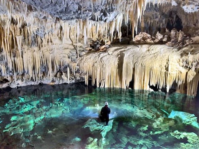
The Alepotrypa cave is an archaeological site in the Mani region of the Peloponnese peninsula. In addition to being inhabited by early farmers, this site was used for burial and cult purposes. Archaeological evidence has revealed that this is one of the largest Neolithic burial sites ever found in Europe. Two adult human skeletons were found at the site from a burial dating to the 4th millennium BC, as well as remains from at least 170 separate persons. Archaeologists are uncertain about the significance of a Mycenaen ossuary, which has been dated to the 2nd millennium BC and appears to have been reburied at Alepotrypa. While there is no direct evidence, it is possible that the ossuary may link Alepotrypa to Tainaron, which was regarded as the entrance to Hades in classical mythology.
During the Neolithic era, the cave itself served as a burial site while farmers inhabited a large village outside the cave. Based on evidence found at the site, archaeologists believe that the early farmers who inhabited this area ate mostly barley and wheat, and suggest that non-lethal head injuries found on the skulls may indicate violent confrontations.
Primary burial, cremation and secondary burial are all represented at the site, and it was also used for shelter and storage.
Evidence of cultic practice has also been found, including the head of a stalagmite type marble idol.
Other finds from the excavation include Late Neolithic stone, pottery and clay vessels, jewelry and weapons. Painted and incised pottery, shell beads, stone axes, and a complete flint arrowhead have been found, along with blades and flakes of Melian obsidian.
Silver jewelry found at the site suggests the area was wealthy, as silver was extremely rare in Bronze Age and Neolithic Europe.
A rare early copper axe, which scholars believe can be dated to the Final Neolithic period, was also found at the Alepotrypa site.
Paul Cartledge writes that "there was apparently no transitional Chalcolithic phase in the Peloponnese" and adds that the copper tools found in the Alepotrypa cave "provide a convenient transition" to the Early Helladic era.
Mythological tradition says there was an entrance to the underworld domain of the Greek god of death Hades at the nearby site of Tainaron, and archaeologists working on the excavation believe it is possible that the cultural memory of the burial site at Alepotrypa had become associated with Tainaron by the classical period.
Archaeologists have speculated that a later Mycenaean ossuary dating from 1300 BC may have been carried to the site for reburial during the late Bronze Age.
One possible explanation offered by the lead excavator Giorgos Papathanassopoulos is that the persons who inhabited this site took the cultural memory of an underground realm where the dead were buried with them.
Anastasia Papathanasiou, co-director of the Diros excavation added that "there's no direct evidence, but we can't rule out that possibility".
9 localnici recomandă
Diros
The Alepotrypa cave is an archaeological site in the Mani region of the Peloponnese peninsula. In addition to being inhabited by early farmers, this site was used for burial and cult purposes. Archaeological evidence has revealed that this is one of the largest Neolithic burial sites ever found in Europe. Two adult human skeletons were found at the site from a burial dating to the 4th millennium BC, as well as remains from at least 170 separate persons. Archaeologists are uncertain about the significance of a Mycenaen ossuary, which has been dated to the 2nd millennium BC and appears to have been reburied at Alepotrypa. While there is no direct evidence, it is possible that the ossuary may link Alepotrypa to Tainaron, which was regarded as the entrance to Hades in classical mythology.
During the Neolithic era, the cave itself served as a burial site while farmers inhabited a large village outside the cave. Based on evidence found at the site, archaeologists believe that the early farmers who inhabited this area ate mostly barley and wheat, and suggest that non-lethal head injuries found on the skulls may indicate violent confrontations.
Primary burial, cremation and secondary burial are all represented at the site, and it was also used for shelter and storage.
Evidence of cultic practice has also been found, including the head of a stalagmite type marble idol.
Other finds from the excavation include Late Neolithic stone, pottery and clay vessels, jewelry and weapons. Painted and incised pottery, shell beads, stone axes, and a complete flint arrowhead have been found, along with blades and flakes of Melian obsidian.
Silver jewelry found at the site suggests the area was wealthy, as silver was extremely rare in Bronze Age and Neolithic Europe.
A rare early copper axe, which scholars believe can be dated to the Final Neolithic period, was also found at the Alepotrypa site.
Paul Cartledge writes that "there was apparently no transitional Chalcolithic phase in the Peloponnese" and adds that the copper tools found in the Alepotrypa cave "provide a convenient transition" to the Early Helladic era.
Mythological tradition says there was an entrance to the underworld domain of the Greek god of death Hades at the nearby site of Tainaron, and archaeologists working on the excavation believe it is possible that the cultural memory of the burial site at Alepotrypa had become associated with Tainaron by the classical period.
Archaeologists have speculated that a later Mycenaean ossuary dating from 1300 BC may have been carried to the site for reburial during the late Bronze Age.
One possible explanation offered by the lead excavator Giorgos Papathanassopoulos is that the persons who inhabited this site took the cultural memory of an underground realm where the dead were buried with them.
Anastasia Papathanasiou, co-director of the Diros excavation added that "there's no direct evidence, but we can't rule out that possibility".
One of the most impressive caves of Greece can be found near the village of Kastania on the southern tip of the Peloponnese, just minutes away from Neapoli. The route follows the winding mountain road leading to the forest-covered eastern slopes of Mt. Parnon.
Rich in density and variety of shapes, colors and figures, Kastania Cave is classified as second of its kind in Europe. Nature needed three million years to create this fantasyscape with its unparalleled décor and numerous impressive formations such as enormous red and white “waterfalls”, the gigantic columns, the “curtains” and the “sheets” that overflow like waxwork from the roof, “octopuses” and “corals” nest, “elephants” and “mushrooms”, “birds” and caricatures, “exotic plants” and monumental creatures…
Standing out among the numerous attractions of the cave are geological rarities such as discs, flat stalagmites, eccentrites and elictites. With a little luck, visitors may meet the cave’s noble resident insect, the deaf and blind dolichopoda.
The cave’s surface covers 1,500 square meters separated into two levels and the visitor is guided along a 500-meter route. The cave was formed from limestones of Jurassic age (195-145 million years old) as a result of geological turmoil and chemical reaction. The stone décor owes its seven-color palette to crystalline carbonate lime enriched with several metal oxides.
Kastania
One of the most impressive caves of Greece can be found near the village of Kastania on the southern tip of the Peloponnese, just minutes away from Neapoli. The route follows the winding mountain road leading to the forest-covered eastern slopes of Mt. Parnon.
Rich in density and variety of shapes, colors and figures, Kastania Cave is classified as second of its kind in Europe. Nature needed three million years to create this fantasyscape with its unparalleled décor and numerous impressive formations such as enormous red and white “waterfalls”, the gigantic columns, the “curtains” and the “sheets” that overflow like waxwork from the roof, “octopuses” and “corals” nest, “elephants” and “mushrooms”, “birds” and caricatures, “exotic plants” and monumental creatures…
Standing out among the numerous attractions of the cave are geological rarities such as discs, flat stalagmites, eccentrites and elictites. With a little luck, visitors may meet the cave’s noble resident insect, the deaf and blind dolichopoda.
The cave’s surface covers 1,500 square meters separated into two levels and the visitor is guided along a 500-meter route. The cave was formed from limestones of Jurassic age (195-145 million years old) as a result of geological turmoil and chemical reaction. The stone décor owes its seven-color palette to crystalline carbonate lime enriched with several metal oxides.
The Mani Peninsula (Greek: Μάνη, romanized: Mánē), also long known by its medieval name Maina or Maïna (Μαΐνη), is a geographical and cultural region in southern Greece that is home to the Maniots (Mανιάτες, Maniátes in Greek), who claim descent from the ancient Spartans. The capital cities of Mani are Gytheio and Areopoli. Mani is the central peninsula of the three which extend southwards from the Peloponnese in southern Greece. To the east is the Laconian Gulf, to the west the Messenian Gulf. The Mani peninsula forms a continuation of the Taygetos mountain range, the western spine of the Peloponnese.
The terrain is mountainous and inaccessible.
Until recent years many Mani villages could be reached only by sea. Today a narrow and winding road extends along the west coast from Kalamata to Areopoli, then south to Akrotainaro (the pointed cape, which is the southernmost point of continental Greece) before it turns north toward Gytheio. Another road, that is used by the public buses of the Piraeus - Mani line, which has existed for several decades, comes from Tripoli through Sparta, Gytheio, Areopoli and ends in the Gerolimenas port near Cape Matapan. Mani has been traditionally divided into three regions:
• Exo Mani (Έξω Μάνη) or Outer Mani to the northwest,
• Kato Mani (Κάτω Μάνη) or Lower Mani to the east,
• Mesa Mani (Μέσα Μάνη) or Inner Mani to the southwest.
A fourth region named Vardounia (Βαρδούνια) to the north is also sometimes included but was never historically part of Mani. Vardounia served as a buffer between the Ottoman-Turkish controlled Evrotas plains and Mani. A contingent of Muslim Albanian settlers were relocated to the region by the Ottomans. These settlers formed a large segment of the local population until the Greek War of Independence when they fled to the Turkish stronghold at Tripoli.[2] Following the war Vardounia's Greek population was reinforced by settlers from Lower Mani and central Laconia.
Administratively, Mani is now divided between the prefectures of Laconia (Kato Mani, Mesa Mani) and Messenia (Exo Mani), in the periphery of Peloponnesos, but in ancient times it lay entirely within Laconia, the district dominated by Sparta. The Messenian Mani (also called aposkiaderi, a local expression meaning "shady") receives somewhat more rainfall than the Laconian (called prosiliaki, a local expression meaning "sunny"), and is consequently more productive in agriculture. Maniots from what is now Messenian Mani have surnames that uniformly end in -éas, whereas Maniots from what is now Laconian Mani have surnames that end in -ákos; additionally there is the -óggonas ending, a corruption of éggonos, "grandson".
6 localnici recomandă
Mani Peninsula
The Mani Peninsula (Greek: Μάνη, romanized: Mánē), also long known by its medieval name Maina or Maïna (Μαΐνη), is a geographical and cultural region in southern Greece that is home to the Maniots (Mανιάτες, Maniátes in Greek), who claim descent from the ancient Spartans. The capital cities of Mani are Gytheio and Areopoli. Mani is the central peninsula of the three which extend southwards from the Peloponnese in southern Greece. To the east is the Laconian Gulf, to the west the Messenian Gulf. The Mani peninsula forms a continuation of the Taygetos mountain range, the western spine of the Peloponnese.
The terrain is mountainous and inaccessible.
Until recent years many Mani villages could be reached only by sea. Today a narrow and winding road extends along the west coast from Kalamata to Areopoli, then south to Akrotainaro (the pointed cape, which is the southernmost point of continental Greece) before it turns north toward Gytheio. Another road, that is used by the public buses of the Piraeus - Mani line, which has existed for several decades, comes from Tripoli through Sparta, Gytheio, Areopoli and ends in the Gerolimenas port near Cape Matapan. Mani has been traditionally divided into three regions:
• Exo Mani (Έξω Μάνη) or Outer Mani to the northwest,
• Kato Mani (Κάτω Μάνη) or Lower Mani to the east,
• Mesa Mani (Μέσα Μάνη) or Inner Mani to the southwest.
A fourth region named Vardounia (Βαρδούνια) to the north is also sometimes included but was never historically part of Mani. Vardounia served as a buffer between the Ottoman-Turkish controlled Evrotas plains and Mani. A contingent of Muslim Albanian settlers were relocated to the region by the Ottomans. These settlers formed a large segment of the local population until the Greek War of Independence when they fled to the Turkish stronghold at Tripoli.[2] Following the war Vardounia's Greek population was reinforced by settlers from Lower Mani and central Laconia.
Administratively, Mani is now divided between the prefectures of Laconia (Kato Mani, Mesa Mani) and Messenia (Exo Mani), in the periphery of Peloponnesos, but in ancient times it lay entirely within Laconia, the district dominated by Sparta. The Messenian Mani (also called aposkiaderi, a local expression meaning "shady") receives somewhat more rainfall than the Laconian (called prosiliaki, a local expression meaning "sunny"), and is consequently more productive in agriculture. Maniots from what is now Messenian Mani have surnames that uniformly end in -éas, whereas Maniots from what is now Laconian Mani have surnames that end in -ákos; additionally there is the -óggonas ending, a corruption of éggonos, "grandson".
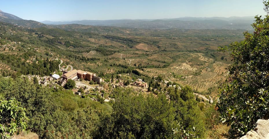
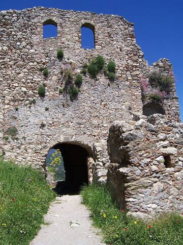
Mystras or Mistras (Greek: Μυστρᾶς/Μιστρᾶς),[2] also known as Myzithras (Μυζηθρᾶς) in the Chronicle of the Morea, is a fortified town and a former municipality in Laconia, Peloponnese, Greece. Situated on Mt. Taygetos, near ancient Sparta, it served as the capital of the Byzantine Despotate of the Morea in the 14th and 15th centuries, experiencing a period of prosperity and cultural flowering. The site remained inhabited throughout the Ottoman period, when it was mistaken by Western travellers for ancient Sparta. In the 1830s, it was abandoned and the new town of Sparti was built, approximately eight kilometres to the east.
In late 1248, William II of Villehardouin, ruler of the Frankish Principality of Achaea, captured Monemvasia, the last remaining Byzantine outpost on the Morea. This success was soon followed by the submission of the restive Tsakones on Mount Parnon, the Slavic Melingoi tribe of Mount Taygetos, and the inhabitants of the Mani peninsula, thereby extending his sway over all of Laconia and completing the conquest of the peninsula, which had begun in 1205, in the aftermath of the Fourth Crusade.[5] Laconia was incorporated into the princely domain, and the young prince passed the winter of 1248–49 there, touring the country and selecting sites for new fortifications such as Grand Magne and Leuktron; finally, near his residence of Lacedaemon (ancient Sparta), on a spur of Mount Taygetos, he built the fortress that came to be known as Mystras.[2][6]
In September 1259, William of Villehardouin was defeated and captured, along with many of his nobles, at the Battle of Pelagonia, by the forces of the Nicaean emperor Michael VIII Palaiologos. Two years later, the Nicaeans recaptured Constantinople, putting an end to the Latin Empire and restoring the Byzantine Empire. At this point, the emperor concluded an agreement with the captive prince: William and his men would be set free in exchange for an oath of fealty, and for the cession of Monemvasia, Grand Magne, and Mystras.[7] The handover was effected in 1262, and henceforth Mystras was the seat of the governor of the Byzantine territories in the Morea. Initially this governor (kephale) was changed every year, but after 1308 they started being appointed for longer terms.[2] Almost immediately on his return to the Morea, William of Villehardouin renounced his oath to the emperor, and warfare broke out between Byzantines and Franks. The first Byzantine attempts to subdue the Principality of Achaea were beaten back in the battles of Prinitsa and Makryplagi, but the Byzantines were firmly ensconced in Laconia. Warfare became endemic, and the Byzantines slowly pushed the Franks back.[8] The insecurity engendered by the raids and counter-raids caused the inhabitants of Lacedaemon to abandon their exposed city and settle at Mystras, in a new town built under the shadow of the fortress.[2]
From 1348 until its surrender to the Ottoman Turks on 31 May 1460, Mystras was the residence of a Despot who ruled over the Byzantine Morea, known as the "Despotate of the Morea". This was the city's golden age; according to the Oxford Dictionary of Byzantium, Mystras "witnessed a remarkable cultural renaissance, including the teaching of Plethon [..], and attracted artists and architects of the highest quality".[2]
The frescos in the Peribleptos Monastery Church, dating between 1348 and 1380, are a very rare surviving late Byzantine cycle, crucial for the understanding of Byzantine art.
Mystras was also the last centre of Byzantine scholarship; the Neoplatonist philosopher George Gemistos Plethon lived there until his death in 1452. He and other scholars based in Mystras influenced the Italian Renaissance, especially after he accompanied the emperor John VIII Palaiologos to Florence in 1439.
The last Byzantine emperor, Constantine XI Palaiologos, was despot at Mystras before he came to the throne. Demetrius Palaeologus the last despot of Morea, surrendered the city to the Ottoman emperor Mehmed II in 1460. As Mezistre, it was the seat of a Turkish sanjak. The Venetians occupied it from 1687 to 1715, but otherwise the Ottomans held it until 1821 and the beginning of the Greek War of Independence. It was abandoned under King Otto for the newly rebuilt town of Sparta.
In 1989 the ruins, including the fortress, palace, churches, and monasteries, were named a UNESCO World Heritage Site.
69 localnici recomandă
Mystras
Mystras or Mistras (Greek: Μυστρᾶς/Μιστρᾶς),[2] also known as Myzithras (Μυζηθρᾶς) in the Chronicle of the Morea, is a fortified town and a former municipality in Laconia, Peloponnese, Greece. Situated on Mt. Taygetos, near ancient Sparta, it served as the capital of the Byzantine Despotate of the Morea in the 14th and 15th centuries, experiencing a period of prosperity and cultural flowering. The site remained inhabited throughout the Ottoman period, when it was mistaken by Western travellers for ancient Sparta. In the 1830s, it was abandoned and the new town of Sparti was built, approximately eight kilometres to the east.
In late 1248, William II of Villehardouin, ruler of the Frankish Principality of Achaea, captured Monemvasia, the last remaining Byzantine outpost on the Morea. This success was soon followed by the submission of the restive Tsakones on Mount Parnon, the Slavic Melingoi tribe of Mount Taygetos, and the inhabitants of the Mani peninsula, thereby extending his sway over all of Laconia and completing the conquest of the peninsula, which had begun in 1205, in the aftermath of the Fourth Crusade.[5] Laconia was incorporated into the princely domain, and the young prince passed the winter of 1248–49 there, touring the country and selecting sites for new fortifications such as Grand Magne and Leuktron; finally, near his residence of Lacedaemon (ancient Sparta), on a spur of Mount Taygetos, he built the fortress that came to be known as Mystras.[2][6]
In September 1259, William of Villehardouin was defeated and captured, along with many of his nobles, at the Battle of Pelagonia, by the forces of the Nicaean emperor Michael VIII Palaiologos. Two years later, the Nicaeans recaptured Constantinople, putting an end to the Latin Empire and restoring the Byzantine Empire. At this point, the emperor concluded an agreement with the captive prince: William and his men would be set free in exchange for an oath of fealty, and for the cession of Monemvasia, Grand Magne, and Mystras.[7] The handover was effected in 1262, and henceforth Mystras was the seat of the governor of the Byzantine territories in the Morea. Initially this governor (kephale) was changed every year, but after 1308 they started being appointed for longer terms.[2] Almost immediately on his return to the Morea, William of Villehardouin renounced his oath to the emperor, and warfare broke out between Byzantines and Franks. The first Byzantine attempts to subdue the Principality of Achaea were beaten back in the battles of Prinitsa and Makryplagi, but the Byzantines were firmly ensconced in Laconia. Warfare became endemic, and the Byzantines slowly pushed the Franks back.[8] The insecurity engendered by the raids and counter-raids caused the inhabitants of Lacedaemon to abandon their exposed city and settle at Mystras, in a new town built under the shadow of the fortress.[2]
From 1348 until its surrender to the Ottoman Turks on 31 May 1460, Mystras was the residence of a Despot who ruled over the Byzantine Morea, known as the "Despotate of the Morea". This was the city's golden age; according to the Oxford Dictionary of Byzantium, Mystras "witnessed a remarkable cultural renaissance, including the teaching of Plethon [..], and attracted artists and architects of the highest quality".[2]
The frescos in the Peribleptos Monastery Church, dating between 1348 and 1380, are a very rare surviving late Byzantine cycle, crucial for the understanding of Byzantine art.
Mystras was also the last centre of Byzantine scholarship; the Neoplatonist philosopher George Gemistos Plethon lived there until his death in 1452. He and other scholars based in Mystras influenced the Italian Renaissance, especially after he accompanied the emperor John VIII Palaiologos to Florence in 1439.
The last Byzantine emperor, Constantine XI Palaiologos, was despot at Mystras before he came to the throne. Demetrius Palaeologus the last despot of Morea, surrendered the city to the Ottoman emperor Mehmed II in 1460. As Mezistre, it was the seat of a Turkish sanjak. The Venetians occupied it from 1687 to 1715, but otherwise the Ottomans held it until 1821 and the beginning of the Greek War of Independence. It was abandoned under King Otto for the newly rebuilt town of Sparta.
In 1989 the ruins, including the fortress, palace, churches, and monasteries, were named a UNESCO World Heritage Site.
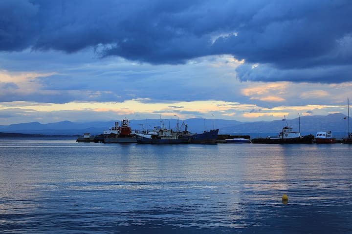
Gytheio or Gythio is a town on the eastern shore of the Mani Peninsula, and a former municipality in Laconia, Peloponnese, Greece. Since the 2011 local government reform it is part of the municipality East Mani, of which it is a municipal unit.
The municipal unit has an area of 197.313 km2. It was the seaport of Sparta, some 40 kilometres (25 miles) north. Gytheio is the site of ancient Cranae, a tiny island where according to legend Paris of Troy and Helen from Sparta spent their first night together before departing for Troy, thus igniting the Trojan War.
Gytheio used to be an important port until it was destroyed in 4th century AD, possibly by an earthquake. Even thereafter its strategic location gave Gytheio a significant role in Maniot history. Today it is the largest and most important town in Mani. It is also the seat of the municipality of East Mani.
Gytheio is located in the northeastern corner of the Mani Peninsula and lies on the northwestern end of the Laconian Gulf. Gytheio was built on a hill called Koumaros or Laryssio in one of the most fertile areas in Mani, near the mouth of the Gythium River, which is usually dry and has been nicknamed Xerias "dry river"; today, most of the Xerias is covered by Ermou Avenue.
Directly north and visible from the harbor is Profitis Ilias, the ultra-prominent peak of Taygetus, the mountain range whose spine juts southward into the Mediterranean Sea and forms the Mani Peninsula.
On the ridgeline running south from Profitis Ilias sits the Monastery of Panayia Yiatrissa overlooking the valley toward Gytheio; the E4 hiking path connects the three, running south from Profitis Ilias, passing by the monastery, and leading to Gytheio.
Northeast of Gytheio is the delta of the Evrotas River. Offshore are several small islands; the most important of these islands is Cranae, on which sits the Tzannetakis Tower (now the Historical and Cultural museum of Mani) and a lighthouse built of solid marble. Today Cranae is connected to the mainland by a causeway.
Approximately 5 km (3 mi) southwest is a passageway to the deeper Mani, historically guarded by Castle Passavas (now in ruins), which towers over the site of ancient Las. Further west is the historic city of Areopoli and the Caves of Diros, which are important tourist attractions.
Gytheio is only 40 km (25 mi) southeast of Sparti, connected by Greek National Road 39. The town center is situated around the port. Pine trees are situated in the west and rocky mountains in the north.
30 localnici recomandă
Gytheio
Gytheio or Gythio is a town on the eastern shore of the Mani Peninsula, and a former municipality in Laconia, Peloponnese, Greece. Since the 2011 local government reform it is part of the municipality East Mani, of which it is a municipal unit.
The municipal unit has an area of 197.313 km2. It was the seaport of Sparta, some 40 kilometres (25 miles) north. Gytheio is the site of ancient Cranae, a tiny island where according to legend Paris of Troy and Helen from Sparta spent their first night together before departing for Troy, thus igniting the Trojan War.
Gytheio used to be an important port until it was destroyed in 4th century AD, possibly by an earthquake. Even thereafter its strategic location gave Gytheio a significant role in Maniot history. Today it is the largest and most important town in Mani. It is also the seat of the municipality of East Mani.
Gytheio is located in the northeastern corner of the Mani Peninsula and lies on the northwestern end of the Laconian Gulf. Gytheio was built on a hill called Koumaros or Laryssio in one of the most fertile areas in Mani, near the mouth of the Gythium River, which is usually dry and has been nicknamed Xerias "dry river"; today, most of the Xerias is covered by Ermou Avenue.
Directly north and visible from the harbor is Profitis Ilias, the ultra-prominent peak of Taygetus, the mountain range whose spine juts southward into the Mediterranean Sea and forms the Mani Peninsula.
On the ridgeline running south from Profitis Ilias sits the Monastery of Panayia Yiatrissa overlooking the valley toward Gytheio; the E4 hiking path connects the three, running south from Profitis Ilias, passing by the monastery, and leading to Gytheio.
Northeast of Gytheio is the delta of the Evrotas River. Offshore are several small islands; the most important of these islands is Cranae, on which sits the Tzannetakis Tower (now the Historical and Cultural museum of Mani) and a lighthouse built of solid marble. Today Cranae is connected to the mainland by a causeway.
Approximately 5 km (3 mi) southwest is a passageway to the deeper Mani, historically guarded by Castle Passavas (now in ruins), which towers over the site of ancient Las. Further west is the historic city of Areopoli and the Caves of Diros, which are important tourist attractions.
Gytheio is only 40 km (25 mi) southeast of Sparti, connected by Greek National Road 39. The town center is situated around the port. Pine trees are situated in the west and rocky mountains in the north.
Food scene
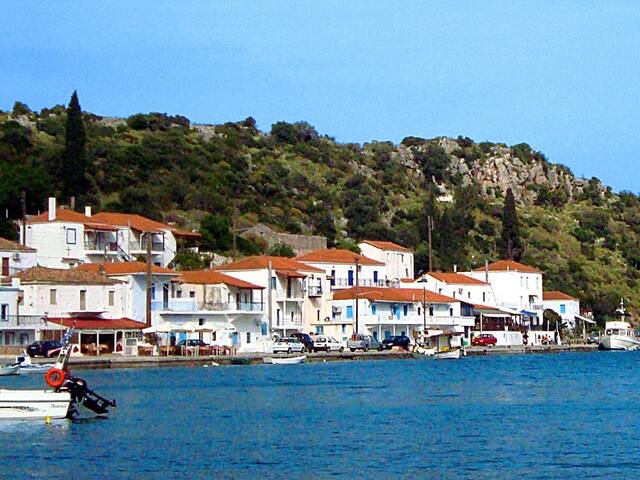
Gerakas sits on a big salt water marsh and lake at the end of a narrow passageway from the sea. Gerakas is probably the most sheltered little harbor in Greece and as such a popular place for yachts and sailboats who can spend the night here and not worry about the changing winds or rough seas. Because of this the port area has several very nice little restaurants, cafes and ouzeries. Being a completely closed harbor it is not the best place for swimming as there does not seem to be any real beach, but people swim off the rocks in the channel.
Gerakas
Gerakas sits on a big salt water marsh and lake at the end of a narrow passageway from the sea. Gerakas is probably the most sheltered little harbor in Greece and as such a popular place for yachts and sailboats who can spend the night here and not worry about the changing winds or rough seas. Because of this the port area has several very nice little restaurants, cafes and ouzeries. Being a completely closed harbor it is not the best place for swimming as there does not seem to be any real beach, but people swim off the rocks in the channel.