
Area Guidebook!
Sightseeing and various fun places!
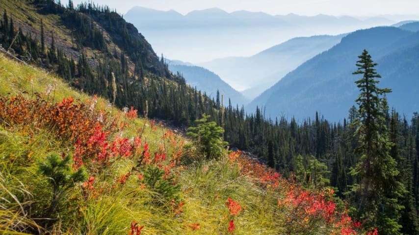
Montana's Jewel Basin is a day hiker's paradise and only a half-hour drive from downtown Kalispell. The area is studded with 25 alpine lakes and offers 35 miles of hiking trails and expansive views of the Flathead Valley to the west and Hungry Horse Reservoir and the Great Bear Wilderness to the east.
Hikes range from easy to strenuous depending on which route you choose. All trails involve some elevation gain.
Pika boo, A pika in the Jewel Basin area – Danny Nestor
Fall huckleberry color, Jewel Basin, huckleberry and beargrass bushes, NW Montana – Dee Linnell Blank
Jewel Reflections, The photographers son enjoying crystal-clear waters of Picnic Lakes in the Jewel Basin. – Ian Cameron
Pika boo, A pika in the Jewel Basin area – Danny Nestor
Fall huckleberry color, Jewel Basin, huckleberry and beargrass bushes, NW Montana – Dee Linnell Blank
Fall huckleberry color, Jewel Basin, huckleberry and beargrass bushes, NW Montana – Dee Linnell Blank
CONTACTS
Flathead National Forest
650 Wolfpack Way
Kalispell, MT 59901
Get Directions
406-758-5200
http://www.fs.usda.gov/attmain/flathead/specialplaces
HIGHLIGHTS AND BEST FEATURES OF THIS TRAIL
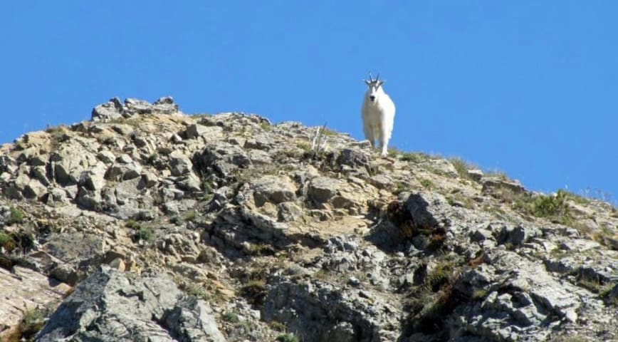
The Jewel Basin is specially designated for hiking and camping only. In addition to dramatic views, the area's 15,349 acres offer wildflower meadows, pristine lakes, and opportunities to see mountain goats and other wildlife. The Montana Department of Fish, Wildlife and Parks stocks some of the lakes with native westslope cutthroat trout on a rotating basis. For specific information about which lakes have been stocked, contact the Department of Fish, Wildlife and Parks, 490 Meridian Road in Kalispell, at 406-755-2701.
Download a PDF of the Jewel Basin Hiking Area Map below.
TRAIL DISTANCE
There are 35 miles of trails of varying distances. Maps of the Jewel Basin and its trails are available at the Kalispell Visitor Information Center, 15 Depot Park. Call 406-758-2809.
TRAIL VERTICAL GAIN OR LOSS
Camp Misery Trailhead is located at 5,717 feet. The highest point in the trail system is the top of Mt. Aeneas at 7,528 feet.
DRIVING DIRECTIONS FROM NEAREST TOWN OR LANDMARK
From Bigfork, Montana take Hwy 35 north to Hwy 83. Head east on Hwy 83 to the junction of the Echo Lake Road. Head north on Echo Lake Road about 3 miles to junction with the Jewel Basin Road (No. 5392). Follow this road approximalty 7 miles to the trailhead. CAUTION: The last 5 miles are steep. Use headlights for safety. Caution advised for low clearance vehicles. Trailers not recommended.
From Kalispell, Montana head east on Highway 2. Where Highway 2 curves and goes north, continue east on Highway 35. Make a left onto Lake Blaine Road which turns into Foothill Road. Foothill Road winds south along the base of the mountains. Turn left onto Jewel Basin Road (FS Road 5392) and follow it about 7 miles to the Camp Misery Trailhead. Caution: the last 5 miles are steep and not recommended for low-clearance vehicles.
ESTIMATED TIME IT TAKES TO EXPERIENCE THIS TRAIL
Plan on a minimum of 3 to 4 hours.
These trails are very popular from June through September. On beautiful summer days, you may share the trails with many fellow hikers (by Montana standards). The parking lot at Camp Misery can be crowded, especially on weekends.
Leaving from Camp Misery, the trail leads uphill through high mountain forests of spruce, fir and whitebark pine. The uppermost elevations of the trail system are above the tree-line.
The trails are mostly well-maintained packed dirt and rock. Be prepared for snow on the trail if you're hiking before the 4th of July. No mountain bikes, horses or motorized vehicles are allowed in the Jewel Basin area.
All dogs must be on leashes. Group size is limited to 12. Camping permits are not required.
105 localnici recomandă
Jewel Basin
Montana's Jewel Basin is a day hiker's paradise and only a half-hour drive from downtown Kalispell. The area is studded with 25 alpine lakes and offers 35 miles of hiking trails and expansive views of the Flathead Valley to the west and Hungry Horse Reservoir and the Great Bear Wilderness to the east.
Hikes range from easy to strenuous depending on which route you choose. All trails involve some elevation gain.
Pika boo, A pika in the Jewel Basin area – Danny Nestor
Fall huckleberry color, Jewel Basin, huckleberry and beargrass bushes, NW Montana – Dee Linnell Blank
Jewel Reflections, The photographers son enjoying crystal-clear waters of Picnic Lakes in the Jewel Basin. – Ian Cameron
Pika boo, A pika in the Jewel Basin area – Danny Nestor
Fall huckleberry color, Jewel Basin, huckleberry and beargrass bushes, NW Montana – Dee Linnell Blank
Fall huckleberry color, Jewel Basin, huckleberry and beargrass bushes, NW Montana – Dee Linnell Blank
CONTACTS
Flathead National Forest
650 Wolfpack Way
Kalispell, MT 59901
Get Directions
406-758-5200
http://www.fs.usda.gov/attmain/flathead/specialplaces
HIGHLIGHTS AND BEST FEATURES OF THIS TRAIL
The Jewel Basin is specially designated for hiking and camping only. In addition to dramatic views, the area's 15,349 acres offer wildflower meadows, pristine lakes, and opportunities to see mountain goats and other wildlife. The Montana Department of Fish, Wildlife and Parks stocks some of the lakes with native westslope cutthroat trout on a rotating basis. For specific information about which lakes have been stocked, contact the Department of Fish, Wildlife and Parks, 490 Meridian Road in Kalispell, at 406-755-2701.
Download a PDF of the Jewel Basin Hiking Area Map below.
TRAIL DISTANCE
There are 35 miles of trails of varying distances. Maps of the Jewel Basin and its trails are available at the Kalispell Visitor Information Center, 15 Depot Park. Call 406-758-2809.
TRAIL VERTICAL GAIN OR LOSS
Camp Misery Trailhead is located at 5,717 feet. The highest point in the trail system is the top of Mt. Aeneas at 7,528 feet.
DRIVING DIRECTIONS FROM NEAREST TOWN OR LANDMARK
From Bigfork, Montana take Hwy 35 north to Hwy 83. Head east on Hwy 83 to the junction of the Echo Lake Road. Head north on Echo Lake Road about 3 miles to junction with the Jewel Basin Road (No. 5392). Follow this road approximalty 7 miles to the trailhead. CAUTION: The last 5 miles are steep. Use headlights for safety. Caution advised for low clearance vehicles. Trailers not recommended.
From Kalispell, Montana head east on Highway 2. Where Highway 2 curves and goes north, continue east on Highway 35. Make a left onto Lake Blaine Road which turns into Foothill Road. Foothill Road winds south along the base of the mountains. Turn left onto Jewel Basin Road (FS Road 5392) and follow it about 7 miles to the Camp Misery Trailhead. Caution: the last 5 miles are steep and not recommended for low-clearance vehicles.
ESTIMATED TIME IT TAKES TO EXPERIENCE THIS TRAIL
Plan on a minimum of 3 to 4 hours.
These trails are very popular from June through September. On beautiful summer days, you may share the trails with many fellow hikers (by Montana standards). The parking lot at Camp Misery can be crowded, especially on weekends.
Leaving from Camp Misery, the trail leads uphill through high mountain forests of spruce, fir and whitebark pine. The uppermost elevations of the trail system are above the tree-line.
The trails are mostly well-maintained packed dirt and rock. Be prepared for snow on the trail if you're hiking before the 4th of July. No mountain bikes, horses or motorized vehicles are allowed in the Jewel Basin area.
All dogs must be on leashes. Group size is limited to 12. Camping permits are not required.
Whitefish Mountain Resort
1015 Glades DrGreat place to ski!
Blacktail Mountain Ski Area
13990 Blacktail RoadMore skiing!
Shield Arms
12090 Montana 83If you're looking to buy a firearm or a knife, all made in USA.
Murdoch's Ranch & Home Supply
2330 US-93A fun store for the fam! Grab some Huckleberry honey!
Sporting Goods for all! Enjoy shopping for fun gear, clothes, and fishing and hunting licenses for all seasons.
6 localnici recomandă
Snappy's
1400 U.S. Hwy 2 ESporting Goods for all! Enjoy shopping for fun gear, clothes, and fishing and hunting licenses for all seasons.
Bigfork Anglers Fly Shop
405 Bridge StFishing gear galore!
Trusted Gear Company LLC
2181 U.S. 2Any tactical gear you need!
Liquor Barn
22 Swan WayAny liquor, wine, cider or beer you need! Even Montana favorites!
If you love treasure hunting! There are some great buys here! Joanna Gaines style.
6 localnici recomandă
4th & ZURI
55 4th Ave W NIf you love treasure hunting! There are some great buys here! Joanna Gaines style.
Hiking
Strawberry Lake Trail #5 | Bigfork, Montana
Outdoor Adventures, Hiking Trail or Trailhead
Strawberry Lake Trail is a 2.8 mile trail that ushers you along switchbacks through a lush coniferous forest before opening up to Montana's Flathead Valley views approximately 1.5 miles from Strawberry Lake. Strawberry Lake is a small alpine lake that affords sweeping views of the valley below and is a great picnic or rest stop. For those looking to retreat even further into alpine bliss can connect to the Alpine Trail #7 at the head of the lake. Located near Bigfork, MT, Strawberry Lake Trail is a year round favorite for locals and tends to see heavy usage on summer weekends.
Strawberry Lake Trail meanders through a lush coniferous forest much of the way. – Sheena Pate
Just before reaching Strawberry Lake the trail views open up to the Flathead Valley below. – Sheena Pate
Strawberry Lake Trail meanders through a lush coniferous forest much of the way. – Sheena Pate
Contacts
Flathead National Forest- Swan Lake Ranger District
200 Ranger Station Road
Bigfork, MT 59911
Get Directions
(406) 837-7500
(406) 837-7503
https://www.fs.usda.gov/recarea/flathead/recreation/recarea/?recid=77571
DRIVING DIRECTIONS FROM NEAREST TOWN OR LANDMARK
From Bigfork, go North on Highway 35 for 2.3 miles and turn right onto Highway 83. Stay on 83 for 2.8 miles and turn left onto Echo Lake Rd. After 2.2 miles, turn slightly right onto Foothill Rd. bear left after 1.1 miles to stay on the Foothill Rd. Drive for 2.7 miles, then turn right onto Road 5390 and drive for 3.3 miles, the trailhead is located at the end of this road.
HIGHLIGHTS AND BEST FEATURES OF THIS TRAIL
Strawberry Lake offers a small gravel beach for resting or play.
Access to Alpine Trail #7 with the option to travel north another 27 miles to Columbia Mountain, the terminus of the Swan Range.
Access to the northern section of Jewel Basin Hiking Area and Wildcat Lake. Don't forget to bring your fly rod!
TRAIL DISTANCE
2.8 Miles One-Way
TRAIL VERTICAL GAIN OR LOSS
7 localnici recomandă
Strawberry Lake
Strawberry Lake Trail #5 | Bigfork, Montana
Outdoor Adventures, Hiking Trail or Trailhead
Strawberry Lake Trail is a 2.8 mile trail that ushers you along switchbacks through a lush coniferous forest before opening up to Montana's Flathead Valley views approximately 1.5 miles from Strawberry Lake. Strawberry Lake is a small alpine lake that affords sweeping views of the valley below and is a great picnic or rest stop. For those looking to retreat even further into alpine bliss can connect to the Alpine Trail #7 at the head of the lake. Located near Bigfork, MT, Strawberry Lake Trail is a year round favorite for locals and tends to see heavy usage on summer weekends.
Strawberry Lake Trail meanders through a lush coniferous forest much of the way. – Sheena Pate
Just before reaching Strawberry Lake the trail views open up to the Flathead Valley below. – Sheena Pate
Strawberry Lake Trail meanders through a lush coniferous forest much of the way. – Sheena Pate
Contacts
Flathead National Forest- Swan Lake Ranger District
200 Ranger Station Road
Bigfork, MT 59911
Get Directions
(406) 837-7500
(406) 837-7503
https://www.fs.usda.gov/recarea/flathead/recreation/recarea/?recid=77571
DRIVING DIRECTIONS FROM NEAREST TOWN OR LANDMARK
From Bigfork, go North on Highway 35 for 2.3 miles and turn right onto Highway 83. Stay on 83 for 2.8 miles and turn left onto Echo Lake Rd. After 2.2 miles, turn slightly right onto Foothill Rd. bear left after 1.1 miles to stay on the Foothill Rd. Drive for 2.7 miles, then turn right onto Road 5390 and drive for 3.3 miles, the trailhead is located at the end of this road.
HIGHLIGHTS AND BEST FEATURES OF THIS TRAIL
Strawberry Lake offers a small gravel beach for resting or play.
Access to Alpine Trail #7 with the option to travel north another 27 miles to Columbia Mountain, the terminus of the Swan Range.
Access to the northern section of Jewel Basin Hiking Area and Wildcat Lake. Don't forget to bring your fly rod!
TRAIL DISTANCE
2.8 Miles One-Way
TRAIL VERTICAL GAIN OR LOSS
Mount Aeneas Trail #717 ushers you through sub-alpine spruce forest before climbing up to a ridge traverse to Mount Aeneas (7,528 feet), the highest point in the hikers-only Jewel Basin. Hike out-and-back to summit or drop down to Picnic Lakes for a loop hike back to Camp Misery Trailhead. From the summit enjoy dramatic views of the area's 15,349 acres wildflower meadows, mountains and pristine lakes and beyond to Glacier National Park to the north and Flathead Valley to the west.
It is likely you will encounter or spot mountain goats on the summit. If they happen to be on trail give them plenty of space and either wait for them to move along or hike off trail long enough to get around them.
CONTACTS
Flathead National Forest- Supervisor Office
650 Wolfpack Way
Kalispell, MT 59901
Get Directions
(406) 758-5208
https://www.fs.usda.gov/activity/flathead/recreation/hiking
Camp Misery Trailhead is the most popular trailhead for the Jewel Basin Hiking Area and parking area can fill up quickly on weekends. Beat the crowds and plan on hiking weekdays or arrive early on Saturday or later on Sundays.
TRAIL DISTANCE
4 - 6 miles depending on chosen route
TRAIL VERTICAL GAIN OR LOSS
1,800 feet gain
TRAIL CONDITION REPORT
Click HERE for current trail condition reports from the United States Forest Service. These are updated at least bi-weekly June to October.
KNOW BEFORE YOU GO
There a vault toilet only at Camp Misery Trailhead.
Bring water, layers and food.
You are in bear country! Always bring bear spray and be aware of your surroundings.
ADVENTURE SMART
If getting out into the great outdoors is a new endeavor we welcome you and ask you to learn about Leave No Trace Principles and Recreate Responsibly before heading out. Also, we recommend checking out Adventure Smart for tips on how to explore safely. If you're a seasoned adventurer it never hurts to brush up on proper practices too.
DRIVING DIRECTIONS FROM NEAREST TOWN OR LANDMARK
From Bigfork, Montana take Hwy 35 north to Hwy 83. Head east on Hwy 83 to the junction of the Echo Lake Road. Head north on Echo Lake Road about 3 miles to junction with the Jewel Basin Road (No. 5392). Follow this road approximalty 7 miles to the trailhead. CAUTION: The last 5 miles are steep. Use headlights for safety. Caution advised for low clearance vehicles. Trailers not recommended.
From Camp Misery Trailhead, go to gated dirt road and begin hike up Trail #717. It will be an easy ascent to the first ridge where the road transitions into a trail about 0.8 miles in. At trail fork take the middle trail (Trail #717) and ascend up to next ridge. Continue about a mile up long switchbacks to the top of ridge. Follow ridge trail to the south to Mount Aeneas Summit.
Opt to hike a loop and continue on Trail #717 down north side of Mount Aeneas
16 localnici recomandă
Mount Aeneas
Mount Aeneas Trail #717 ushers you through sub-alpine spruce forest before climbing up to a ridge traverse to Mount Aeneas (7,528 feet), the highest point in the hikers-only Jewel Basin. Hike out-and-back to summit or drop down to Picnic Lakes for a loop hike back to Camp Misery Trailhead. From the summit enjoy dramatic views of the area's 15,349 acres wildflower meadows, mountains and pristine lakes and beyond to Glacier National Park to the north and Flathead Valley to the west.
It is likely you will encounter or spot mountain goats on the summit. If they happen to be on trail give them plenty of space and either wait for them to move along or hike off trail long enough to get around them.
CONTACTS
Flathead National Forest- Supervisor Office
650 Wolfpack Way
Kalispell, MT 59901
Get Directions
(406) 758-5208
https://www.fs.usda.gov/activity/flathead/recreation/hiking
Camp Misery Trailhead is the most popular trailhead for the Jewel Basin Hiking Area and parking area can fill up quickly on weekends. Beat the crowds and plan on hiking weekdays or arrive early on Saturday or later on Sundays.
TRAIL DISTANCE
4 - 6 miles depending on chosen route
TRAIL VERTICAL GAIN OR LOSS
1,800 feet gain
TRAIL CONDITION REPORT
Click HERE for current trail condition reports from the United States Forest Service. These are updated at least bi-weekly June to October.
KNOW BEFORE YOU GO
There a vault toilet only at Camp Misery Trailhead.
Bring water, layers and food.
You are in bear country! Always bring bear spray and be aware of your surroundings.
ADVENTURE SMART
If getting out into the great outdoors is a new endeavor we welcome you and ask you to learn about Leave No Trace Principles and Recreate Responsibly before heading out. Also, we recommend checking out Adventure Smart for tips on how to explore safely. If you're a seasoned adventurer it never hurts to brush up on proper practices too.
DRIVING DIRECTIONS FROM NEAREST TOWN OR LANDMARK
From Bigfork, Montana take Hwy 35 north to Hwy 83. Head east on Hwy 83 to the junction of the Echo Lake Road. Head north on Echo Lake Road about 3 miles to junction with the Jewel Basin Road (No. 5392). Follow this road approximalty 7 miles to the trailhead. CAUTION: The last 5 miles are steep. Use headlights for safety. Caution advised for low clearance vehicles. Trailers not recommended.
From Camp Misery Trailhead, go to gated dirt road and begin hike up Trail #717. It will be an easy ascent to the first ridge where the road transitions into a trail about 0.8 miles in. At trail fork take the middle trail (Trail #717) and ascend up to next ridge. Continue about a mile up long switchbacks to the top of ridge. Follow ridge trail to the south to Mount Aeneas Summit.
Opt to hike a loop and continue on Trail #717 down north side of Mount Aeneas
Clayton Lake is in the Flathead National Forest's well traveled Jewel Basin Hiking Area, but its position on the far east side of the basin affords it fewer visitors. It is a gradual climb from the east side access leading hikers through thick alder for the first half of the hike up to the lake. As you approach lake it opens up, but is still timbered. Hike around the Clayton Lake and/or explore more of the Jewel Basin trail system beyond. The Clayton Creek Trail is 2.9 miles long and begins at Clayton Creek Road #1633 and ends at Jct. Tongue Trail. #55 - Clayton Lake.
CONTACTS
Flathead National Forest- Supervisor Office
650 Wolfpack Way
Kalispell, MT 59901
Get Directions
(406) 758-5208
https://www.fs.usda.gov/activity/flathead/recreation/hiking
Flathead County Trails
MT
Get Directions
http://flathead.maps.arcgis.com/apps/PublicInformation/index.html?appid=653b9965737740d48642397185a38265
DRIVING DIRECTIONS FROM NEAREST TOWN OR LANDMARK
Follow the directions to the Camp Misery Trailhead (west side access) or access from the Westside Reservior Road #895, then to Clayton Creek Road #1633 (east side access).
Columbia Falls, Montana to Westside Reservoir Road #895/Clayton Creek TH (east side access): 1 h 20 min (30.4 miles) Follow US-2 E to NF-895/West Side Rd in Hungry Horse, Continue on NF-895/West Side Rd. Drive to NF-1633
Bigfork, Montana to Westside Reservoir Road #895/Clayton Creek TH (east side access): 1 h 44 min (52.1 miles) Take Commerce St to MT-35 W, Continue on MT-35 W. Take Montana Hwy 206 to NF-895/West Side Rd in Hungry Horse, Continue on NF-895/West Side Rd. Drive to NF-1633
Bigfork, Montana to Camp Misery Trailhead (west side access): 40 min (14.1 miles) From Bigfork head north on Bigfork Stage Rd. Turn right onto MT-83 S. Make a left onto Echo Lake Rd which turns into Foothill Road. Foothill Road winds south along the base of the mountains. Turn left onto Jewel Basin Road (FS Road 5392) and follow it about 7 miles to the Camp Misery Trailhead. Caution: the last 5 miles are steep and not recommended for low-clearance vehicles**.**
Kalispell, Montana to Camp Misery Trailhead (west side access): 1 h (32.5 miles) From Kalispell, head east on Highway 2. Where Highway 2 curves and goes north, continue east on Highway 35. Make a left onto Lake Blaine Road which turns into Foothill Road. Foothill Road winds south along the base of the mountains. Turn left onto Jewel Basin Road (FS Road 5392) and follow it about 7 miles to the Camp Misery Trailhead. Caution: the last 5 miles are steep and not recommended for low-clearance vehicles.
TRAIL DISTANCE
From Hungry Horse Reservoir (east side access) it's 2.3 miles to Clayton Lake and a 12.4-mile roundtrip hike from the commonly used Camp Misery trailhead on the west side.
TRAIL VERTICAL GAIN OR LOSS
1,600 foot gain

Hungry Horse Mountain
Clayton Lake is in the Flathead National Forest's well traveled Jewel Basin Hiking Area, but its position on the far east side of the basin affords it fewer visitors. It is a gradual climb from the east side access leading hikers through thick alder for the first half of the hike up to the lake. As you approach lake it opens up, but is still timbered. Hike around the Clayton Lake and/or explore more of the Jewel Basin trail system beyond. The Clayton Creek Trail is 2.9 miles long and begins at Clayton Creek Road #1633 and ends at Jct. Tongue Trail. #55 - Clayton Lake.
CONTACTS
Flathead National Forest- Supervisor Office
650 Wolfpack Way
Kalispell, MT 59901
Get Directions
(406) 758-5208
https://www.fs.usda.gov/activity/flathead/recreation/hiking
Flathead County Trails
MT
Get Directions
http://flathead.maps.arcgis.com/apps/PublicInformation/index.html?appid=653b9965737740d48642397185a38265
DRIVING DIRECTIONS FROM NEAREST TOWN OR LANDMARK
Follow the directions to the Camp Misery Trailhead (west side access) or access from the Westside Reservior Road #895, then to Clayton Creek Road #1633 (east side access).
Columbia Falls, Montana to Westside Reservoir Road #895/Clayton Creek TH (east side access): 1 h 20 min (30.4 miles) Follow US-2 E to NF-895/West Side Rd in Hungry Horse, Continue on NF-895/West Side Rd. Drive to NF-1633
Bigfork, Montana to Westside Reservoir Road #895/Clayton Creek TH (east side access): 1 h 44 min (52.1 miles) Take Commerce St to MT-35 W, Continue on MT-35 W. Take Montana Hwy 206 to NF-895/West Side Rd in Hungry Horse, Continue on NF-895/West Side Rd. Drive to NF-1633
Bigfork, Montana to Camp Misery Trailhead (west side access): 40 min (14.1 miles) From Bigfork head north on Bigfork Stage Rd. Turn right onto MT-83 S. Make a left onto Echo Lake Rd which turns into Foothill Road. Foothill Road winds south along the base of the mountains. Turn left onto Jewel Basin Road (FS Road 5392) and follow it about 7 miles to the Camp Misery Trailhead. Caution: the last 5 miles are steep and not recommended for low-clearance vehicles**.**
Kalispell, Montana to Camp Misery Trailhead (west side access): 1 h (32.5 miles) From Kalispell, head east on Highway 2. Where Highway 2 curves and goes north, continue east on Highway 35. Make a left onto Lake Blaine Road which turns into Foothill Road. Foothill Road winds south along the base of the mountains. Turn left onto Jewel Basin Road (FS Road 5392) and follow it about 7 miles to the Camp Misery Trailhead. Caution: the last 5 miles are steep and not recommended for low-clearance vehicles.
TRAIL DISTANCE
From Hungry Horse Reservoir (east side access) it's 2.3 miles to Clayton Lake and a 12.4-mile roundtrip hike from the commonly used Camp Misery trailhead on the west side.
TRAIL VERTICAL GAIN OR LOSS
1,600 foot gain
Jewel Basin
A gorgeous place to hike adjacent to us!
Food scene
Echo Lake Café | Bigfork, Montana
Echo Lake Café serves wholesome food with exceptional views of the Swan Mountain Range, in NW Montana. Established in the 1960s, the cafe has remained the heartbeat of the community and a favorite spot to stop before exploring the Jewel Basin and Swan Valley for locals and visitors.
– courtesy of Keith Hammer
CONTACTS
BOB AND CHRISTIE YOUNG
Echo Lake Cafe
1195 MT Hwy. 83
Bigfork, MT 59911
Get Directions
406-837-4252
http://www.echolakecafe.com/
DRIVING DIRECTIONS
From Bigfork, MT to Echo Lake Cafe (approx. 10 minute drive)
Take Commerce St to MT-35 W, Drive to MT-83 S, Echo Lake Cafe will be on the right side of road
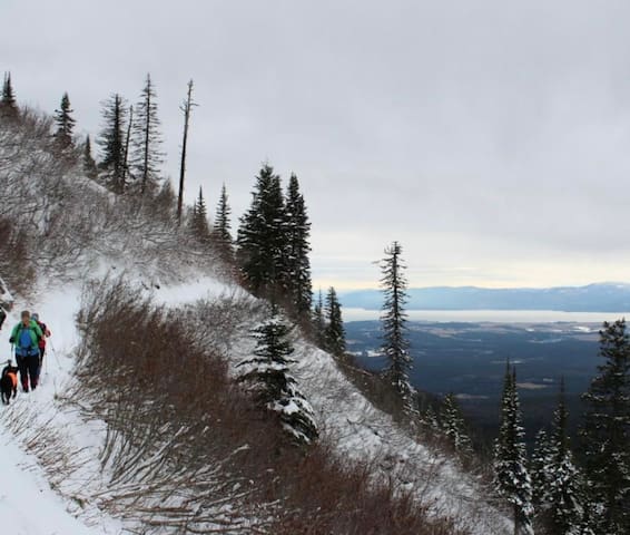
Join the Swan Rangers here for breakfast before the hiking club’s Saturday outings by boot, snowshoe, or ski. The Swan Rangers hiking club meets at the Café every Saturday morning for breakfast and a partial day outing of hiking, snowshoeing or cross-country skiing in the nearby Swan Range. The outings are documented along with photos and educational information about the Swan Range at www.swanrange.org.
This collaboration between business and recreation is aimed to foster an appreciation of nature and a commitment to its long-term stewardship.
Here are the year-round Saturday meeting times for the Swan Rangers:
May 1 - October 31: 7:30 Breakfast and 8:30 Departure November 1 - April 30: 8:30 Breakfast and 9:30 Departure
93 localnici recomandă
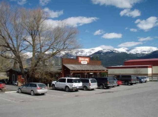
Echo Lake Cafe
1195 MT-83Echo Lake Café | Bigfork, Montana
Echo Lake Café serves wholesome food with exceptional views of the Swan Mountain Range, in NW Montana. Established in the 1960s, the cafe has remained the heartbeat of the community and a favorite spot to stop before exploring the Jewel Basin and Swan Valley for locals and visitors.
– courtesy of Keith Hammer
CONTACTS
BOB AND CHRISTIE YOUNG
Echo Lake Cafe
1195 MT Hwy. 83
Bigfork, MT 59911
Get Directions
406-837-4252
http://www.echolakecafe.com/
DRIVING DIRECTIONS
From Bigfork, MT to Echo Lake Cafe (approx. 10 minute drive)
Take Commerce St to MT-35 W, Drive to MT-83 S, Echo Lake Cafe will be on the right side of road
Join the Swan Rangers here for breakfast before the hiking club’s Saturday outings by boot, snowshoe, or ski. The Swan Rangers hiking club meets at the Café every Saturday morning for breakfast and a partial day outing of hiking, snowshoeing or cross-country skiing in the nearby Swan Range. The outings are documented along with photos and educational information about the Swan Range at www.swanrange.org.
This collaboration between business and recreation is aimed to foster an appreciation of nature and a commitment to its long-term stewardship.
Here are the year-round Saturday meeting times for the Swan Rangers:
May 1 - October 31: 7:30 Breakfast and 8:30 Departure November 1 - April 30: 8:30 Breakfast and 9:30 Departure
Looking for a bite and possibly some music!? Swing by the A Bar!
15 localnici recomandă
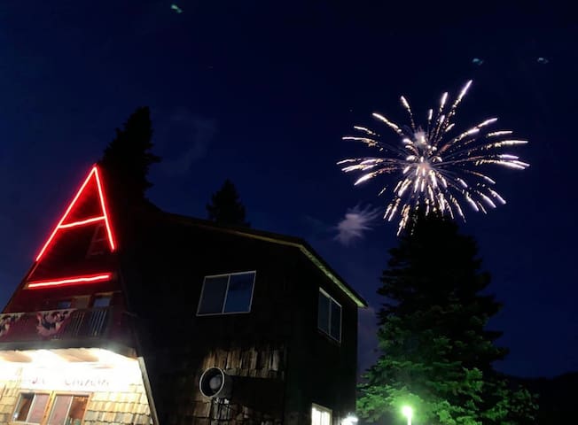
A Bar, Montana
11032 MT-83Looking for a bite and possibly some music!? Swing by the A Bar!
Bigfork Harvest Foods
8111 Montana Hwy 35The closest grocery store!
Rosa's Pizza
8585 Montana Hwy 35Great local pizza!
Fieldheads Coffee Roasting Co.
482 Osborn AveGreat locally roasted coffee!
Montana Bonfire
15300 Montana Hwy 35Great food!
Oro Y Plata
408 Bridge StreetYour taco needs!
City/town information
Kalispell
Downtown Kalispell if adorable and has great shopping!