
Rob's Guidebook
Sightseeing
Nice place to visit with level spot at river’s edge to picnic on the ground beside the water. Bridge sways side to side as you walk across. About 7.2 miles on pavement from campsite plus 3.2 miles on gravel road. Apx. 500 yds hike from parking area to bridge along a well worn path.
If you want a longer hike there is limited parking along Hwy 60 at the turn off to the bridge. Take the trail to and from the swinging bridge. 7.2 miles round trip hiking.
112 localnici recomandă
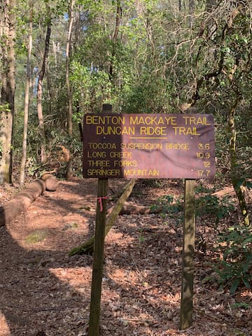
Swinging Bridge on the Toccoa River
Swinging Bridge on the Toccoa RiverNice place to visit with level spot at river’s edge to picnic on the ground beside the water. Bridge sways side to side as you walk across. About 7.2 miles on pavement from campsite plus 3.2 miles on gravel road. Apx. 500 yds hike from parking area to bridge along a well worn path.
If you want a longer hike there is limited parking along Hwy 60 at the turn off to the bridge. Take the trail to and from the swinging bridge. 7.2 miles round trip hiking.
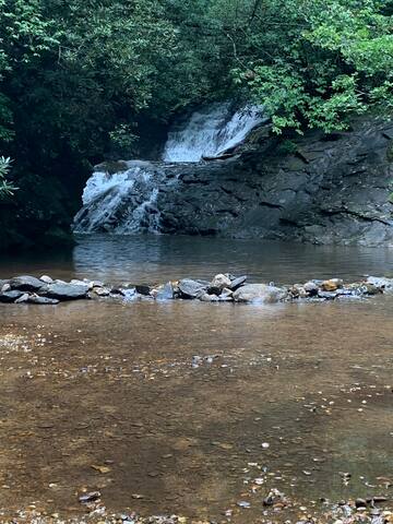
Easy, level hike from the parking area ending at the bottom of a series of three connected falls. Wade in the shallows at the bottom of the pool or go in waist deep.
Look for the remains of old rock masonry work to the left of the bottom pool. May have served as an anchor point on the left side for a log or wood dam across the creek.
The trail continues up the left side of the creek to the top of the falls for those willing to risk climbing a narrow path where a stumble or slip could send you falling 20 ft to the rocks below.
18 minutes, 7.5 miles away.
If turning off Hwy 60 onto Cooper Creek Rd. go 2.9 miles to the gravel road and sign on the left.
NOTE: when the road reaches an open area for parking don’t drive through the creek on the right! Park in the open area and walk out at the end of the parking area and you will find the trail.
8 localnici recomandă
Sea Creek Falls Trailhead
Sea Creek RoadEasy, level hike from the parking area ending at the bottom of a series of three connected falls. Wade in the shallows at the bottom of the pool or go in waist deep.
Look for the remains of old rock masonry work to the left of the bottom pool. May have served as an anchor point on the left side for a log or wood dam across the creek.
The trail continues up the left side of the creek to the top of the falls for those willing to risk climbing a narrow path where a stumble or slip could send you falling 20 ft to the rocks below.
18 minutes, 7.5 miles away.
If turning off Hwy 60 onto Cooper Creek Rd. go 2.9 miles to the gravel road and sign on the left.
NOTE: when the road reaches an open area for parking don’t drive through the creek on the right! Park in the open area and walk out at the end of the parking area and you will find the trail.
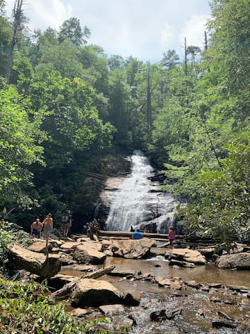
The trail to the wood viewing platform at it’s end is perhaps the most interesting part of a visit. On one visit a laminated picture of a Copperhead warning about snakes was tacked to a tree. I did see a 4 ft long snake crossing the trail- but not a venomous kind. There are groundwork steps and bridges and walking platforms but still some slick areas along the path.
If you arrived from the turnoff from Hwy 129, leave the parking area by going down hill. This route will take you through two shallow fords of the creek where you drive through the water.
A 45 minute drive from the campsite.
109 localnici recomandă
Helton Creek Falls
The trail to the wood viewing platform at it’s end is perhaps the most interesting part of a visit. On one visit a laminated picture of a Copperhead warning about snakes was tacked to a tree. I did see a 4 ft long snake crossing the trail- but not a venomous kind. There are groundwork steps and bridges and walking platforms but still some slick areas along the path.
If you arrived from the turnoff from Hwy 129, leave the parking area by going down hill. This route will take you through two shallow fords of the creek where you drive through the water.
A 45 minute drive from the campsite.
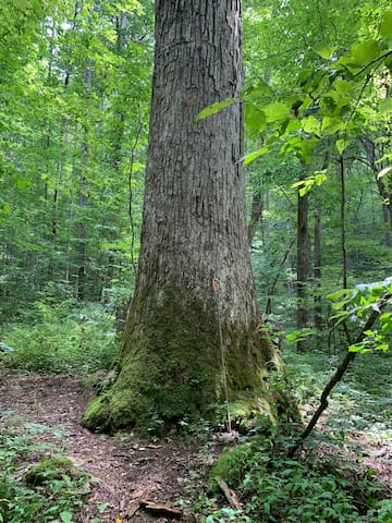
Nice hike with added benefits of large tree specimens. Expect to have blowdowns across the path that you must walk around or climb over. Elevation changes can cause you to pause to catch your breath but nothing too exhausting. Several large poplar trees along the trail. My pictures don’t convey the size well because there isn’t anyone in the pictures for scale. The largest one is close to 6’ in diameter at measuring height (about 5’ above the ground). About 10’ at ground level. 6’ might not seem like much but if you look at a queen size bed this tree would be wider than the mattress- and the frame.
When you near the top of the mountain you will see a large tree below and above the trail. Don’t turn around there but follow the trail over the top and down the backside of the mountain. When you see the large tree with the hollow trunk on the right then the largest tree will be down the trail apx. 85 yds on the left.
About 2 miles and 5 minutes away to where you park and take the trail. I had zero phone reception from start to finish.
Valley of the Giants
Nice hike with added benefits of large tree specimens. Expect to have blowdowns across the path that you must walk around or climb over. Elevation changes can cause you to pause to catch your breath but nothing too exhausting. Several large poplar trees along the trail. My pictures don’t convey the size well because there isn’t anyone in the pictures for scale. The largest one is close to 6’ in diameter at measuring height (about 5’ above the ground). About 10’ at ground level. 6’ might not seem like much but if you look at a queen size bed this tree would be wider than the mattress- and the frame.
When you near the top of the mountain you will see a large tree below and above the trail. Don’t turn around there but follow the trail over the top and down the backside of the mountain. When you see the large tree with the hollow trunk on the right then the largest tree will be down the trail apx. 85 yds on the left.
About 2 miles and 5 minutes away to where you park and take the trail. I had zero phone reception from start to finish.
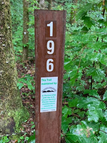
Cooper Creek “Eyes on Wildlife Trail”. A nice loop hiking trail with views of coves with some sizable trees at points and ferns covering the ground at others. No views of adjacent mountains or skylines, at least not when the leaves are still on the trees.
You can choose the difficulty of the trail by choosing which way you start up. The elevation gain is 272 feet but the gain is accomplished in half the distance when you take the right path as when you take the left path.
Take the left path up if you want an easier climb.
Starting right the trail up has several wet/rocky spots so be careful passing over those and use your walking staff for stability.
You can hear Cooper Creek on your right on the way up and Tom Jones Branch on your right on the way down.
If you do take the right trail up be careful to look for a hair pin switch back off the level part of the trail as you descend. It’s easy to miss when the weeds and shrubs are still flourishing and you’re taking in the sights in front of and around you. If the path you’re following becomes less worn and narrower you probably missed the switchback down the mountain.
1.7 mile trail including the walk from the parking lot across the gravel road and wood foot bridge.
2.9 miles - 10 minutes from the campsite.
10 localnici recomandă
Cooper Creek Recreation Area
Forest Service Road 236Cooper Creek “Eyes on Wildlife Trail”. A nice loop hiking trail with views of coves with some sizable trees at points and ferns covering the ground at others. No views of adjacent mountains or skylines, at least not when the leaves are still on the trees.
You can choose the difficulty of the trail by choosing which way you start up. The elevation gain is 272 feet but the gain is accomplished in half the distance when you take the right path as when you take the left path.
Take the left path up if you want an easier climb.
Starting right the trail up has several wet/rocky spots so be careful passing over those and use your walking staff for stability.
You can hear Cooper Creek on your right on the way up and Tom Jones Branch on your right on the way down.
If you do take the right trail up be careful to look for a hair pin switch back off the level part of the trail as you descend. It’s easy to miss when the weeds and shrubs are still flourishing and you’re taking in the sights in front of and around you. If the path you’re following becomes less worn and narrower you probably missed the switchback down the mountain.
1.7 mile trail including the walk from the parking lot across the gravel road and wood foot bridge.
2.9 miles - 10 minutes from the campsite.